

Look at map! Click > New York City Hurricane Evacuation Zones - Interactive Map - NYTimes.com
Wunderground says elevation is 43ft.
Click > Clermont, NJ Weather Forecast from Weather Underground
I would have love to be an:
astronaut.
pilot
actress/singer
Clermont is a populated place located in Cape May County at latitude 39.151 and longitude -74.763.
The elevation is 13 feet. Clermont appears on the Woodbine U.S. Geological Survey Map. Cape May County is in the Eastern Time Zone (UTC -5 hours).
Click for more information: Clermont Populated Place Profile / Cape May County, New Jersey Data
Click > http://www.freemaptools.com/radius-around-point.htm
Scroll down to "options" and in the "Place radius by location name :" put in Lexington MO. Then go to "Radius Distance" (which is already preset) clear those boxes and put in 50. Now go back to the location name and click on "Draw Radius.
Since this was posted two years ago, I thought I'll try answering using Microsoft Word. I still need practice! How do you make a graph?
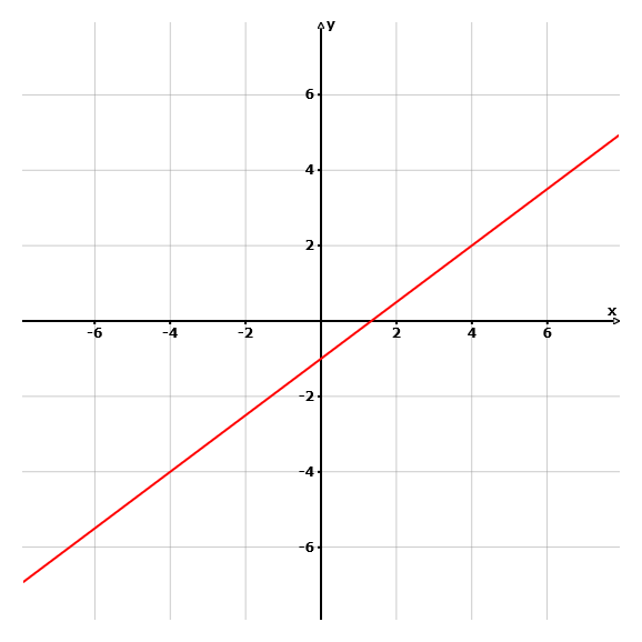
Write an Equation in Slope – Intercept Form
A line passes through (4, 2) and (0, -1)
x1 y1 x2 y2
1. Slope: m = y2 – y1 / x2 – x1
-1 – 2 / 0 – 4
m = -3/-4
m = 3/4
2. Y – Intercept: y = mx + b > use either ordered pair
2 = 3/4(4) + b
2 = 12/4 + b
2 = 3 + b
-3 -3____
-1 = b
3. Plug – in > write equation:
y = mx + b
y = 3/4x - 1
If you graph this equation starting on the y-axis -1, move up 3 then to the right 4, repeat, move up 3 to the right 4. You will see (4, 2) and (0, -1) on the graph.
First, they play 'Heart and Soul', then 'Chopsticks.